Our 2019 grand trailer pull took us through all five National Parks in Utah, aka the Mighty 5. We spent three weeks hiking/touring Zion, Bryce Canyon, Capitol Reef, Canyonlands, and Arches. We researched each via the National Park Service (NPS) website and using the most excellent guidebook, Your Guide to the National Parks by Michael Joseph Oswald (Stone Road Press, 2017).
Still, I assumed that the parks would be like touring European cathedrals, i. e., if you have seen one, you have seen them all. My hearty apologies to NPS, Utah, and to all who get how silly a thought that was. Each is unique. Each shows its own character. Each is a joy to visit. NPS has done a wonderful job making each park accessible and enjoyable for the millions of visitors each year. As with any NP the earlier one arrives, the less crowded it is. We were at the gates before the rangers, before the visitor centers opened, and before the 10 o’clock crowds began forming. That gave us breathing time to assess the park’s features and plan our tours/hikes.


I had intended to write a bit about each, their geology, their history, etcetera, but what more can I say that has not already been said. There is copious information available, yet, none of the vicariousness comes remotely close to a real-time experience in each park. So, of the dozens of photos that I took, I selected a few from each park that I believe reflects their own special givings. With those I offer my humble thoughts of each.
Zion (established 1919), the motherload of the M5 is not the biggest (146,598 acres), but its offerings are huge. We were fortunate enough to be there during a rather wet few days which means we got to see the ephemeral water falls rushing down the mountains contributing to the roaring, cascading Virgin River.


Here are a couple of hints, besides not booking during a major holiday. As soon as the Visitors Center opens head for the Ranger information counter. Sign up for the Interpretive Tour. Led by a Park Ranger, you get to hear about and see things that you might miss otherwise. It is a very popular tour that fills up quickly.
Bryce (established 1928) may be my fav (as it is with the 1.7 million visitors annually). It offers great elevation change over 35,835 acres, snow at Rainbow Point, and the magnificent hoodoos. It is so different than Zion in that the geologic formations show more color and appear mystical.

From the vast overlooks at Rainbow Point and Yovimpa Point to the mystical Fairyland Point one finds too much for the eye to take in at one time. Plan on spending a few days to hike down into Bryce Amphitheater.


Keep your eye out for Mule deer, Western Tanager, prairie dogs, and 1300 year old bristlecone pines. Stop in the Visitor Center as soon as it opens and sign up for the Rainbow Point Tour, a 40 mile, 3.5 hour bus ride that stops at eight of the most scenic viewpoints along the main park road.
Traveling Scenic Byway 12 from Bryce Canyon to Capitol Reef you will go through the northern part of the Grand Staircase-Escalante National Monument. It is easy to see why this was the last place in the US to be mapped. 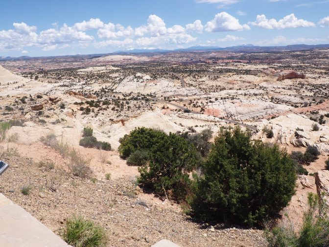 Starkly beautiful, in 2017, President Trump cut its size in half giving commercial mining companies a green light to search for coal, oil/gas, and tar sands.
Capitol Reef (241,000 acres) ( 940,000 visitors annually) has two distinct features: the Waterpocket Fold that runs for 100 miles and Fruita, a now abandoned Mormon settlement. The community of Fruita has an interesting history for its short life. Established around 1880 at the most ten Mormon families lived a hard scrabble life along the Fremont River. Several families planted orchards of pears, peaches, cherries, apricots, and apples.


These still remain accessible to visitors. A short waking tour winds through a park with huge cottonwood trees, along a path through old orchards, and up to the school house. Make sure to buy a pie or two at the Gifford Farmhouse.


Stop at the Petroglyphs Trail along the way. If you are in to heights, try Goosenecks Overlook.
Established in 1964 Canyonlands NP covers over 335,000 acres with more than 200 miles of hiking trails, not to mention the myriad of mining roads. It is so big that NPS divided it into three Districts: Island in the Sky, the Needles, and the Maze. 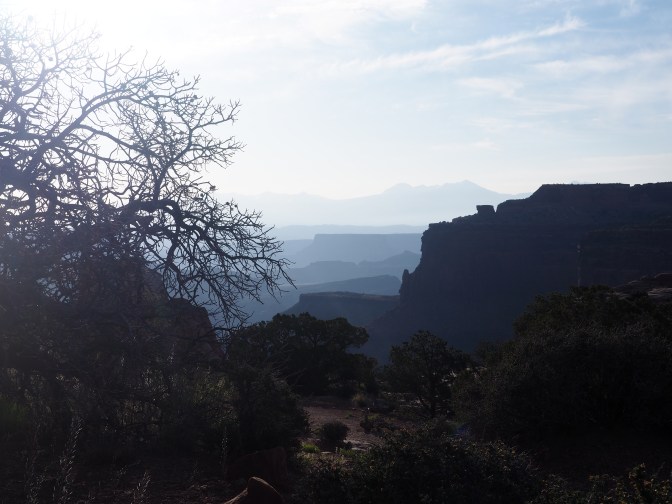 We toured Island in the Sky as it is the most accessible. The overlooks bring you to the edge of canyons with miles of buttes and mesas. Its beauty includes parched deserts and swift rivers. Canyonlands is bordered to the east by the Colorado River and the west by the Green River which merges into the Colorado in The Needles. We cut short our hiking because of the rapidly rising temperature, still we got in a bit of the Upheaval Dome trail.


The Grand View Point Overlook gives one the sensation of the vastness of this park. It also allows a perspective of its geologic age ranging from 1.5 million to over 300 million years ago. Plan well as it is about 30 miles from Moab to the Island in the Sky Visitors Center (634,000 visitors annually).
 We ended our tour of the Mighty 5 at Arches NP, established 1971. Even though it shares the Colorado Plateau with Canyonlands, its uniqueness lies in the over 2000 natural sandstone arches in hues of pink red, and orange.


The arches combine with Petrified Dunes, Windows, and Devils Garden for over 50% of trails that are designated easy to moderate. The beauty of the rock formations from arches to fins to the La Sal Mountain on the eastern horizon are a wonder to behold. (I only imagine what Georgia O’Keefe would have seen and translated to canvas.) again, go early because by noon the park is filled with people and traffic (1.4 million visitors annually). We hiked Park Avenue, Balanced Rock, and the Arches of Double, Windows, Delicate, Sand Dune, Broken, Skyline, and Landscape. What a restful sleep the night was.

Keep your eyes open for our next post. And remember, if we were not here, we would just be someplace else. Happy trails.
